Log in
All resources
Create a design
5,084 Free Artworks of Pages With Maps
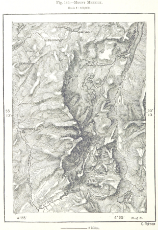
maps from the earth and its inhabitants, vol. iv
maps from the earth and its inhabitants, vol. vii
charles eugène perron
1890s maps showing history
maps from the earth and its inhabitants, vol. vi
picturesque burma, past and present (1897)
maps by willem and johannes blaeu
maps from the mechanical curator collection
19th-century maps of southeast asia
maps indicating exploration
maps from the mechanical curator collection available to georeference
maps from the mechanical curator collection
old maps of manchuria
general atlas (1773)
1870s maps of libya
ghadames
old maps of blankenberge
flandria illustrata
maps from the earth and its inhabitants, vol. iv
maps of river trent
maps from the earth and its inhabitants, vol. vii
charles eugène perron
maps of paris from the david rumsey historical map collection
maps of paris by caspar merian
maps from the earth and its inhabitants, vol. vi
maps of the history of the caucasus
1890s maps of the philippines
old maps of papua new guinea
the comprehensive history of england (1876)
english-language maps showing history
old maps of douarnenez
old maps of brest
atlas van loon
maps of sieges
maps from géographie illustrée de la france et de ses colonies
orientalist painting
the new forest, its history and its scenery
symbolism
maps from the earth and its inhabitants, vol. vii
old maps of jiangsu
maps from the earth and its inhabitants, vol. vii
agricultural maps of china
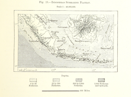
maps from the earth and its inhabitants, vol. ix
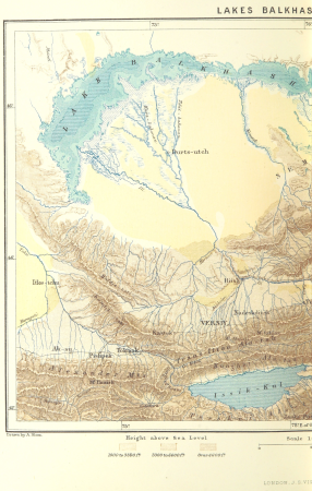
ethnographic maps of asia
picturesque burma, past and present (1897)
1890s maps showing history
maps from the earth and its inhabitants, vol. xi
french west africa
kingdom of bohemia (1867–1918)
20th-century maps of bohemia
old and new london, illustrated (1873) by walter thornbury and edward walford - bl 1887 copy
maps from the mechanical curator collection
maps of the cape of good hope
old maps of cape peninsula
australia (1873) by booth
1870s maps of australia
eran laor cartographic collection
johann ulrich krauß
the new forest, its history and its scenery
symbolism
maps from the earth and its inhabitants, vol. xi
old maps of the sahara
maps from the mechanical curator collection
realism
scrambles amongst the alps
massif de la meije
maps from the earth and its inhabitants, vol. ix
maps indicating exploration
maps in the british museum
jan claesz ten hoorn
maps from the earth and its inhabitants, vol. v
maps of railway lines in norway
maps of edinburgh by braun & hogenberg
18th-century maps of scotland
maps of rivers of equatorial guinea
komo (river)
maps by willem and johannes blaeu
17th-century maps of france
prints by johan frederik clemens in the statens museum for kunst
etching print
maps from the earth and its inhabitants, vol. vii
population density maps of china
maps from the earth and its inhabitants, vol. xviii
maps of the conquest of peru
russian empire in thomas kitchen's general atlas (1773)
general atlas (1773)
maps by willem and johannes blaeu
taro river
atlas sive cosmographicae (gerardus mercator, 1596)
16th-century maps of colombia
maps from the earth and its inhabitants, vol. vi
ferdinand von richthofen
maps from the earth and its inhabitants, vol. vi
population density maps of russia
maps from the earth and its inhabitants, vol. xvi
guillaume le testu
german renaissance
old maps of venice
maps from the earth and its inhabitants, vol. iv
ecclesiastical maps
illustrated title pages from the netherlands
joan blaeu
maps from the mechanical curator collection
1760
petit atlas pittoresque des 48 quartiers de la ville de paris, david rumsey historical map collection
maps of paris from the david rumsey historical map collection
petit atlas pittoresque des 48 quartiers de la ville de paris, david rumsey historical map collection
maps of paris from the david rumsey historical map collection
maps from the earth and its inhabitants, vol. iv
chorley, england
maps from the earth and its inhabitants, vol. vii
charles eugène perron
maps from the earth and its inhabitants, vol. iv
topographic maps of scotland
maps from the earth and its inhabitants, vol. vii
dungan revolt
the history and antiquities of the parish of lambeth, and the archiepiscopal palace (1827)
1820s maps of london
the story of geographical discovery
maps from books
maps from the earth and its inhabitants, vol. vi
old maps of kyrgyzstan
maps from the earth and its inhabitants, vol. iv
falkirk
maps from the earth and its inhabitants, vol. vi
old maps of kyrgyzstan
maps from the earth and its inhabitants, vol. vii
charles eugène perron
maps from the earth and its inhabitants, vol. x
1910s maps of somaliland
maps from the earth and its inhabitants, vol. xiii
somaliland
maps from the earth and its inhabitants, vol. xvii
topographic maps of new york (state)
geographia universalis (1545) in the british museum
german renaissance,northern renaissance
führer durch dalmatien (1899)
salona
redeeming the republic (1890)
1890s maps showing history
a school geography (1898) by bird
old maps of the yellow sea
maps by willem and johannes blaeu
title pages of atlases
maps from the earth and its inhabitants, vol. xiv
maps of the sunda strait
final report of the northwest territory celebration commission
1938 maps of the united states
maps from the earth and its inhabitants, vol. vii
maps of the history of beijing
australia (1873) by booth
1870s maps of australia
maps of the battle of gettysburg
p.s. duval & son
1858 in illinois
1858 maps
maps from the earth and its inhabitants, vol. xiv
1870s maps of new zealand
18th-century copper engravings
jonas haas
the comprehensive history of england (1876)
english-language maps showing history
maps from the earth and its inhabitants, vol. iv
topographic maps of ireland
maps from the earth and its inhabitants, vol. xvii
maps of u.s. water resource subbasins
maps from the earth and its inhabitants, vol. iv
linguistic maps of the united kingdom
maps from the earth and its inhabitants, vol. ix
maps of south india
maps of weather and climate of the united kingdom
maps from the earth and its inhabitants, vol. iv
maps from the earth and its inhabitants, vol. xi
19th-century maps of chad
john rocque's 1746 map of london
old and new london (book)
picturesque burma, past and present (1897)
1890s maps showing history
picturesque burma, past and present (1897)
1890s maps showing history
picturesque burma, past and present (1897)
19th-century maps of myanmar
picturesque burma, past and present (1897)
1890s maps showing history
clifton (bristol ward)
old maps of clifton
clifton (bristol ward)
old maps of clifton
maps by willem and johannes blaeu
title pages of atlases
la palestine (1883, by chardin)
travel maps of palestine
old maps of edinburgh
history of edinburgh
topographia braunschweig lüneburg (merian)
baroque
the earth and its inhabitants, vol. vi: asia, vol. i
title pages of books about geography
untrodden peaks and unfrequented valleys (1873)
old maps of the alps
old maps of the bering sea
old maps of kamchatka
untrodden peaks and unfrequented valleys (1873)
maps of south tyrol
maps of the battle of leipzig
gartenlaube (1863)
civitates orbis terrarum. contrafactur und beschreibung von den vornembsten stetten der welt. liber tertius
maps of fortress of charlemont by braun & hogenberg
maps of carmel valley, california
james meadows
201 - 300 of 5,084
Next page
/ 51